Your Cart is Empty
Get a Personalized Quote×

Overview
Turning the solar energy received by a surface into electricity is a major challenge for cities looking for a quick and efficient transition to sustainable energy systems.
From a complete 3D digital model including terrain, vegetation, buildings any other potentially "masking" elements, RhinoSolar™ allows to evaluate the solar potential of your infrastructures.
Features
RhinoSolar™ calculates the solar potential and the sunshine duration of all surfaces by taking into account the complete 3D digital model to which they belong.
By taking into terrain, vegetation, buildings and all other potentially masking elements, RhinoSolar™ is an unprecedented solution for exploiting a territory's 3D digital model.
|
|
SOLAR ENERGY RhinoSolar™ computes very precisely, taking in account the 3D visibility complex, the 3 components of the solar irradiance :
The global solar irradiance (power in W.m-2) is the sum of these 3 components. |
|
URBAN HEAT ISLAND (UHI)
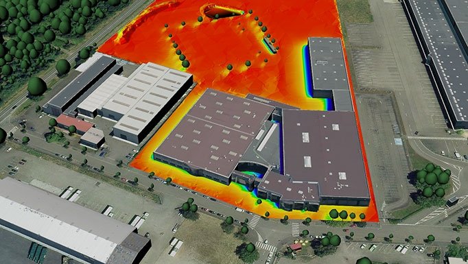
RhinoSolar™ produces usable numerical results in Excel or SQLite, as well as textured 3D models from totally customizable gradients: let your creativity expose the solar potential of your data! |
 |
 |
TAKING INTO ACCOUNT THE COMPLETE 3D MODEL RhinoSolar™ calculates the solar potential and the sunshine duration of all surfaces by taking into account the complete 3D digital model to which they belong. By taking into terrain, vegetation, buildings and all other potentially masking elements, RhinoSolar™ is an unprecedented solution for exploiting a territory's 3D digital model. |
RhinoSolar provides multiple ways of presenting your results:
|
All the characteristics of the studied surfaces (identifier, surface, slope) as well as the results of computation are available as a CSV file directly exploitable in Excel. |
SQLite database export: the high-reliability, embedded, full-featured and public-domain SQL database engine |
Your 3D model is textured for easy reading of the results by gradients with customizable colors. You can also create geo-referenced vertical images of type GeoTiff. |
Exported as attribute data from the 3D geometries studied, the calculation results are directly integrated into the 3D model when exported in CityGML format or in Shapefile (ESRI) format. |


