Your Cart is Empty
Mastering Toposolid Creation in Revit 2025: Enhancing Accuracy for Enscape Visualizations


Creating accurate toposolids in Revit 2025 is critical for architects, landscape architects, and engineers aiming to enhance their project visualizations in Enscape. With the introduction of a new object type in Revit 2024 and 2025, it's essential for users to understand how to generate precise surfaces from civil CAD files. This blog post will guide you through two primary methods for creating a more accurate toposurface in Revit and Enscape, while also discussing the nuances in accuracy between them.
Included with this discussion is a practical video tutorial that demonstrates the process of exporting an AutoCAD Civil 3D surface for use in Revit. Given that Revit and Civil 3D cater to slightly different professional demographics, this guide serves as a bridge for those looking to leverage both tools for enhanced site visualization and accuracy.
Civil CAD Files – Elevated Contours
The most straightforward yet slightly less accurate method involves using civil CAD files defined by elevated contours. Revit utilizes these contours to identify points which are then used to create the toposolid. This approach, while decent in overall accuracy, may omit detailed site features such as spot elevations or connections to architectural elements. Despite these limitations, as demonstrated in our tutorial video, the resultant toposurface can still provide a satisfactory level of detail for many projects.
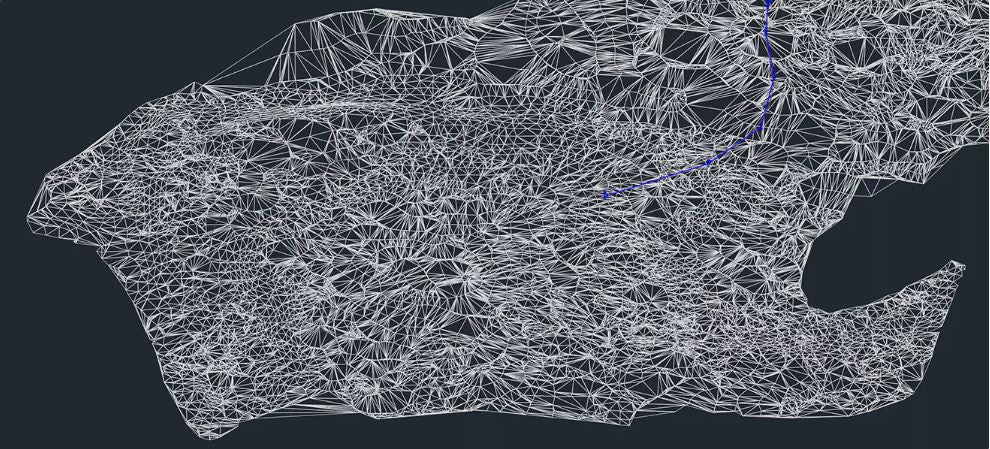
Civil CAD Files – Triangulated Surface
For those seeking higher fidelity in their toposurfaces, requesting a triangulated surface from your civil team is the optimal approach. This method allows Revit to access a greater number of lines for point creation, significantly enhancing the detail and accuracy of the resultant toposolid. The tutorial video clearly shows how this approach yields contours that closely mimic those in AutoCAD Civil 3D, ensuring a higher level of precision in your Revit model.
Adjusting Accurate Contours in Revit
After importing the civil CAD file and creating the toposurface in Revit, you can fine-tune the contour display to align with the original civil CAD file. Adjusting the contour spacing and ensuring the start value is set to zero are crucial steps to achieve graphical and numerical consistency with the original site data.
Enhancing Results in Enscape
Initially, the Enscape visualization may present the surface as triangulated and rough. However, by enabling the Toposolid Smooth Shading option within Revit's Massing and Site tab, users can significantly improve the visual quality of the ground surface. This adjustment results in a smoother and more realistic site model within Enscape, as illustrated in additional views included in our guide.
Comprehensive Video Guide
To ensure clarity in the toposolid creation process within Revit, we have provided a comprehensive video tutorial that outlines both the contour and triangulated surface methods. Additionally, the guide covers the management of shared coordinates within Revit, essential for accurate site representation in both local and BIM 360 projects.
Enscape's Site Context Feature
Enscape’s Site Context feature offers a convenient method for generating an early-phase site context model using OpenStreetMap data. This powerful feature allows for quick integration of urban context into your design visualization, saving hours that would otherwise be spent manually modeling the surrounding buildings.
Conclusion
Accurately creating ground surfaces in CAD/BIM applications like Revit is fundamental for ensuring project coordination and enhancing the visualization and credibility of a design proposal. By following the guidelines outlined in this post and utilizing the advanced features of Revit 2025 and Enscape, designers can achieve highly accurate and visually compelling site representations for their projects. For more information about the newest and most advanced design software technology, contact our sales team at NOVEDGE.
Also in Design News